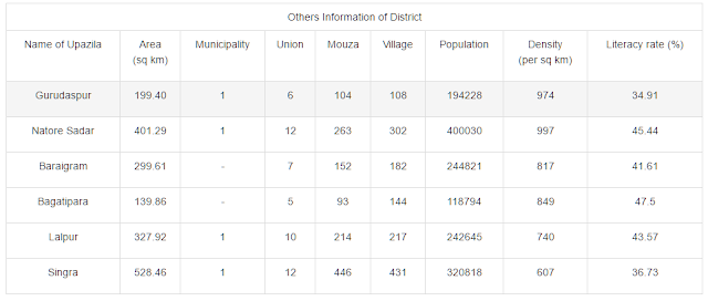
Natore District (rajshahi division) area 1896.05 sq km, located in between 24°25' and 24°58' north latitudes and in between 88°01' and 88°30' east longitudes. It is bounded by naogaon and bogra districts on the north, pabna and kushtia districts on the south, Pabna and sirajganj districts on the east, rajshahi district on the west.
Population Total 698447; male 353201, female 345246; Muslim 549702, Hindu 148339, Buddhist 186, Christian 21 and others 199. Indigenous communities such as santal, oraon, Turi, Bhumij, Kaibarta, Mushar, Malpahadi, munda belong to this upazila.
Water bodies Main rivers: padma, baral, Mara Baral, Baranai, Gurh, nagar; chalan beel 'is notable.
Administration Natore Sub-division, under Rajshahi district, was established in 1845 and it was turned into a district in 1984. Natore Municipality was formed in 1869.
Source Bangladesh Population Census 2001, Bangladesh Bureau of Statistics


No comments:
Post a Comment