Showing posts with label Places Of Interest. Show all posts

Friday, March 25, 2016

Historical Impersonation Of Chalan Beel

The most important factor dominating the river history in Bengal is the large proportion of silt carried by its rivers. It is the silt which has created the land and made it habitable by building it up through the centuries. It is silt which is fertilising the land, but the silt, which has been the most beneficial gift of nature, has also produced most of the river problems now confronting the people of Bengal. Silt deposited in the old river channel beds has forced them to change course, creating problems for abandoned areas while assisting in developing new areas.
The main volume of water from the Ganges River began flowing through the Padma channel in the sixteenth century. Silt from the Padma helped in building up the southern portion of north Bengal. This is the most plausible explanation for the existence of a depression around Chalan Beel. The Teesta was active in the region until it changed its course in 1787. This territory lies in between the land raised in the north by the Teesta system when it was active and that in the south by the Padma.[5]
However, there is another explanation for the creation of the depression. The Padma has been changing its course over the centuries. In Ven den Brouck's map of Bengal, prepared in 1660, the main channel of the Padma is shown as flowing through Faridpur-Bakharganj, but there also is a suggestion of another, possibly earlier channel. This channel runs through Rampur Boalia in Rajshahi, Chalan Beel, Dhaleswari and Buriganga before meeting the Meghna. At that time the Jamuna was virtually non-existent and the Brahmaputra used to flow through its old channel.
Historical depictions of Chalan Beel
Van den Brouck’s map of 1660
James Rennell's map of 1776

Location of main rivers and north bengal


Overview map showing Chalan Beel among the main rivers in North Bengal
Chalan Beel is an extensive lowland area in the lower Atrai basin, and spreads across Singra and 
Gurudaspur upazilas on NatoreDistrict, Chatmohar, Bhangura
 and Faridpur upazilas of Pabna District,and Ullahpara,
 Raiganjand Tarash upazilas of Sirajganj District. It consists of a series of beels connected to one another by various channels to form a continuous water body during the rainy season. Although the beel area expands into a vast water body with dense aquatic vegetation as long as the Jamuna remains flooded during the monsoon months, it dries out in the winter months, leaving only patches of water in the central parts of this zone.
Chalan Beel is fast silting up. In the past it covered an area of about 1,085 km² but was reduced to 368 km² in 1909, of which only 85 km² remained underwater throughout the year. It has since shrunk to only 26 km².
Impact of railways
An estimate taken in 1945 found about 47 rivers and other waterways flowed into the Chalan Beel, a watershed of about 1,547 square miles (4,010 km2). In addition to being a crossroads for the many waterways it also served as the origin for the many rivers flowing south or east that eventually meet with the Padma or Jamuna. In the early 1900s, Chalan Beel began to be hemmed in by the construction of the Eastern Bengal Railway main line on the west and the Santahar-Bogra branch line on the north. The natural pattern of the water's drainage channels in this area were disrupted by the obstruction caused by the railway construction since railways in these low lands had to be built on embankments.

History Of Chalan Beel

Chalan Beel (Bengali: চলনবিল) is a wetland in Bangladesh. It is a large inland depression, marshy in character, with rich flora and fauna. Forty-seven rivers and other waterways flow into the Chalan Beel. As silt builds up in the beel, its size is being reduced.Chalan Beel is an extensive  lowland area in the lower Atrai basin, and spreads across Singra and Gurudaspur upazilas on Natore District, Chatmohar, Bhangura and Faridpur
 upazilas of Pabna District, and Ullahpara, Raiganjand Tarash upazilas of Sirajganj District. It consists of a series of beels connected to one another by variouschannels to form a continuous water body during the rainy season. Although the beel area expands into a vast water body with dense aquatic vegetation as long as the Jamuna remains flooded during the monsoon months, it dries out in the winter months, leaving only patches of water in the central parts of this zone.
Chalan Beel is fast silting up. In the past it covered an area of about 1,085 km² but was reduced to 368 km² in 1909, of which only 85 km² remained underwater throughout the year. It has since shrunk to only 26 km².
History:
The most important factor dominating the river history in Bengal is the large proportion of silt carried by its rivers. It is the silt which has created the land and made it habitable by building it up through the centuries. It is silt which is fertilising the land, but the silt, which has been the most beneficial gift of nature, has also produced most of the river problems now confronting the people of Bengal. Silt deposited in the old river channel beds has forced them to change course, creating problems for abandoned areas while assisting in developing new areas.
The main volume of water from the Ganges River began flowing through the Padma channel in the sixteenth century. Silt from the Padma helped in building up the southern portion of north Bengal. This is the most plausible explanation for the existence of a depression around Chalan Beel. The Teesta was active in the region until it changed its course in 1787. This territory lies in between the land raised in the north by the Teesta system when it was active and that in the south by the Padma.
However, there is another explanation for the creation of the depression. The Padma has been changing its course over the centuries. In Ven den Brouck's map of Bengal, prepared in 1660, the main channel of the Padma is shown as flowing through Faridpur-Bakharganj, but there also is a suggestion of another, possibly earlier channel. This channel runs through Rampur Boalia in Rajshahi, Chalan Beel, Dhaleswari and Buriganga before meeting the Meghna. At that time the Jamuna was virtually
Pollution
Chalan Beel has experienced the negative effects of pesticide use in the surrounding farmlands. In 2010, Bangladesh Agricultural University research, found pesticide use has increased sixfold since 1982, and the fish population of Chalan Beel has halved in the same period. A 25 kilometre highway constructed on the Beel has divided into two and caused havoc on the fish breeding b disrupting their movement. Commercial overfishing, grill and drag net and other destructive fishing have harmed the fish population.

Video Galary of Chalanbil


Wednesday, March 23, 2016

Tourist attractions in Natore District

Tourist attractions in Natore include Rani Bhabanir Rajbari, the palace of Queen Bhabani. Rani Bhabani was a great social worker.[5] She was the pioneer to spread education for the women of Bengal.It is a historical palace, situated in the Bongojol area nearby Natore zero (Madrasamore/old bus stand). There is a college, a school, and other institutions named after Rani Bhobani. Rani Bhabanir Rajbari is surrounded by a wonderful lake, which beautifies this area.
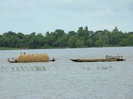
Chalan Beel is a large natural wetland. During the monsoon, the area of the Bil increases and touches four upazilas (sub-districts) of the Natore district. The picnic parties come to Cholon Bil every season. They cook, sing, dance, and do everything they wish in their boats. It looks like a sea, especially during the monsoon.
Dighapatiya Rajbari is the most popular sight with visitors. The kings of Natore lived here. Today, it is called Uttara Gano Bhaban, and is one of the official residences of the president of Bangladesh. It is situated in large grounds, with decorative gates, a large garden, and hundreds of rooms. There is a lake surrounded proper palace area and some spectacular sculpture here. It is 3km distance from Natore Zero point district town.
Front gate of Uttara Gano Bhaban
Other places to visit include:
  • Halti Beel (mini Cox-bazar)
  • Pagla Raja's Palace (jubo park)
  • Palace of Bagatipara Upazila
  • Modoner Pukur Par
  • Natore Adhunik Stadium
  • Maharaja's Palace
  • Beautiful village of Moshinda
  • Natore Sugar Mills
  • North Bengal Sugar Mills and the "Shaheed Sagar" memorial on the mill campus.
  • Pran-Agro Limited
  • Chalan Beel
  • St.Merry Catholic Church which is situated at Bodaigram.